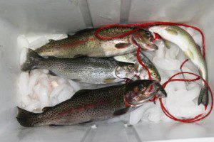
Editor’s Note: Fisherpeople get it: It’s called fishing, not catching. And any fisher who says he/she has never been skunked, or come home empty-handed, has also never been fishing!
But where to fish is the the perpetual question. I work part-time in the fishing department of a sporting goods store. The locals know where to go, but the visitors’ first question is generally “Where can I go to catch some fish?” The store has a “Brag Board” of big fish photos near the entrance and an updated fishing report. But what do you do if these resources are not available?
This fishing app may help fishers in unfamiliar territories.
Understanding map types and angler priorities
by Emma Clarke
Before you set out, choosing the best places to fish can spare you frustration. The difference between a successful fishing trip and a long, fishless day often boils down to understanding how to interpret digital tools alongside practical knowledge. Digital resources make it easier to analyze complex waterways and sort through an overwhelming amount of user-reported tips. These tools put control of your trip firmly in your hands.
Many folks assume that a map is just a simple overview of an area. For anglers, there are important differences that affect safety and results. Base maps tend to show roads, trails, and basic geography, but detailed nautical charts illustrate water depth, submerged structures, channels, and the shape of the river or lake bottom. Knowing how to interpret contours and identify drop-offs, shallow flats, or underwater humps can lead to productive zones while avoiding hazards.

If you fish from shore, map features show public access points and trails and prevent you from wandering into restricted or unsafe areas. Boat anglers rely on maps for launch ramps and understanding navigable routes, especially where submerged timber, sandbars, or sudden changes in water depth might damage a vessel or lead to stranding. Being able to spot transitions between fast and slow water, or locate current seams and structures, lets you predict where feeding fish may congregate at different times.
The role of crowdsourced data in decision-making
Maps provide structure, but crowdsourced data fills in many blanks that a map alone cannot answer. Reports from other anglers often include waypoints, anecdotal notes, launch tips, seasonal changes, and photographs suggesting recent conditions. By sifting through relevant public submissions, you can pick up details about shore stability, parking, wading access, and possible signs of activity like baitfish or water clarity.
Not all crowdsourced reports are useful. For every accurate observation, there can be outliers or exaggerations. Look for repeated information concerning fish movement, which areas are especially popular at particular times, and how weather and water levels affect each spot. Some reports include reminders about local rules or ethical concerns, such as protected fish spawning sites where activity should be minimized. Careful reading makes it easier to separate fact from outdated or misleading tips. This lets you fine-tune your outing.
Balancing reliability, real-time conditions and fishing forecast tools
The best results come from blending static maps and dynamic data to fit current realities. Date and time information attached to reports, and noting how often different users echo the same advice, can give a reasonable measure of a fishing spot. When possible, match the described fishing conditions, like water level, clarity, and temperature, to the present weather forecast, expected tidal movement, and daylight changes for a clearer sense of where fish might be active. This is why a fishing forecast or app paired with first-hand navigation can be useful. Don’t treat any data point as an absolute guarantee. (Here is how to make a simple lure that works really well!)
Fishing forecast tools and apps commonly provide a range of data, including sunrise and sunset times, moon phases, predicted fish activity hours, barometric pressure trends, wind speed and direction, and water temperature. With this information, you can plan times when fish are more likely to be active or feeding, adjust your spot selection based on expected conditions, and avoid periods when a drop in temperature or a sudden weather change could reduce your chances. These tools work best when used alongside your own observations and safe navigation practices. Combine forecast insights with real-world cues for better outcomes.
Ethical responsibilities outdoors
An effective step-by-step process begins with scanning broad regions where fishing access is permitted and conditions align with your goals. Make a short list of three to five potential areas, validate their entry points and hazards and check for temporary closures or conservation measures. Narrow options down by cross-referencing map signals with recent crowdsourced notes, focusing on areas with consistent, non-exaggerated reports.
Upon arrival, look for signs of water clarity, flowing currents, baitfish, or visible structure. These natural cues often reinforce or refute the digital information you have gathered. Always verify that you are not trespassing or violating local fishing regulations, particularly around private property or environmentally sensitive areas! Use digital fishing map apps to record your own observations, compare to previous patterns, and refine your personal knowledge, while remembering to strike a balance between sharing insights and protecting vulnerable habitats for future anglers.

Emma Clarke is a skilled writer with experience across technology, travel, culture, and everyday lifestyle topics. She is adept at breaking down complex subjects into engaging, reader-friendly narratives. Her adaptable approach allows her to bring clarity and quality to a wide range of subjects.